
Stand on the banks of the Thames at Silvertown on a grey, drizzly Tuesday, and they look like silver giants sleeping in the river. Ten massive steel hoods, glistening in the rain, stretching across the water to Charlton on the south bank. To the joggers and dog walkers passing by, they’re just part of the furniture—as much a symbol of London as red buses or the Eye.
But these aren’t statues. They’re the only thing stopping the North Sea from swallowing the capital whole.
For over forty years, the Thames Barrier has been the shield that lets London sleep soundly. It protects £321 billion worth of property, 1.4 million people, the Houses of Parliament, and the Tube network from being inundated by tidal surges. It is a masterpiece of British engineering, a “gatekeeper” that has held back the tide more than 200 times.
But the beast in the river is getting tired. Designed to close just two or three times a year, it is now working harder than its creators ever imagined. Sea levels are rising. Storms are getting angrier. And the timeline for replacing this silver shield is shrinking.
This is the story of London’s high-stakes gamble with nature. It’s a story of terrified families in 1953, of engineers racing against time, and of a future where concrete walls might not be enough to hold back the water.
Please note: The content below may contain affiliate links. If you make a purchase through these links, we could earn a commission, at no additional cost to you.
The Ghost of 1953: Why We Built the Giants
To understand why the barrier exists, you have to go back to a freezing night in January 1953.
Most Londoners today have never seen the Thames truly angry. We see it rising and falling gently with the tide. But the North Sea is a volatile neighbour. On the night of 31st January 1953, a “perfect storm” occurred. A severe gale from the north combined with a high spring tide to create a massive wall of water—a storm surge—that roared down the east coast of Britain.
It didn’t just splash over the sea walls; it smashed through them.
In East Anglia and the Thames Estuary, the devastation was biblical. Families went to bed safe and woke up to freezing seawater rushing into their bedrooms. In Canvey Island, 58 people died as the water engulfed their bungalows. In total, 307 people were killed across the UK that night. It remains the worst natural disaster Britain has faced in living memory.
London itself escaped the worst of the death toll, but only by a whisker. The water lapped just inches from the top of the Embankment in central London. Had it gone over, the Underground would have flooded, thousands would have drowned in basements, and the heart of government would have been paralysed.
That night left a deep scar on the British psyche. It was the “wake-up call” that said: We cannot just build higher walls. We need a gate.
The Long Road to Silver
It took nearly thirty years to go from the disaster of 1953 to a working barrier. Why? Because damming the Thames is a nightmare.
You can’t just build a solid wall because ships need to get through. The Thames is a working highway. The solution came from a brilliant engineer named Charles Draper. The story goes that he was washing up at home when he looked at the gas taps on his cooker. He noticed how the little valve rotated—open to let gas through, closed to stop it.
Why not do that with the river?
He designed massive, hollow steel cylinders that could lie flat on the riverbed, invisible to ships, and then rotate upwards 90 degrees to form a wall when needed. It was a “lightbulb moment” of genius. Construction began in 1974, and it wasn’t an easy ride. It was plagued by strikes, technical headaches, and the sheer difficulty of building underwater in a fast-flowing tidal river.
But in 1982, the “Eighth Wonder of the World” was finally operational. Queen Elizabeth II officially opened it in 1984. London breathed a sigh of relief. The ghost of 1953 had been exorcised. Or so we thought.
The Beast in the River: How It Works
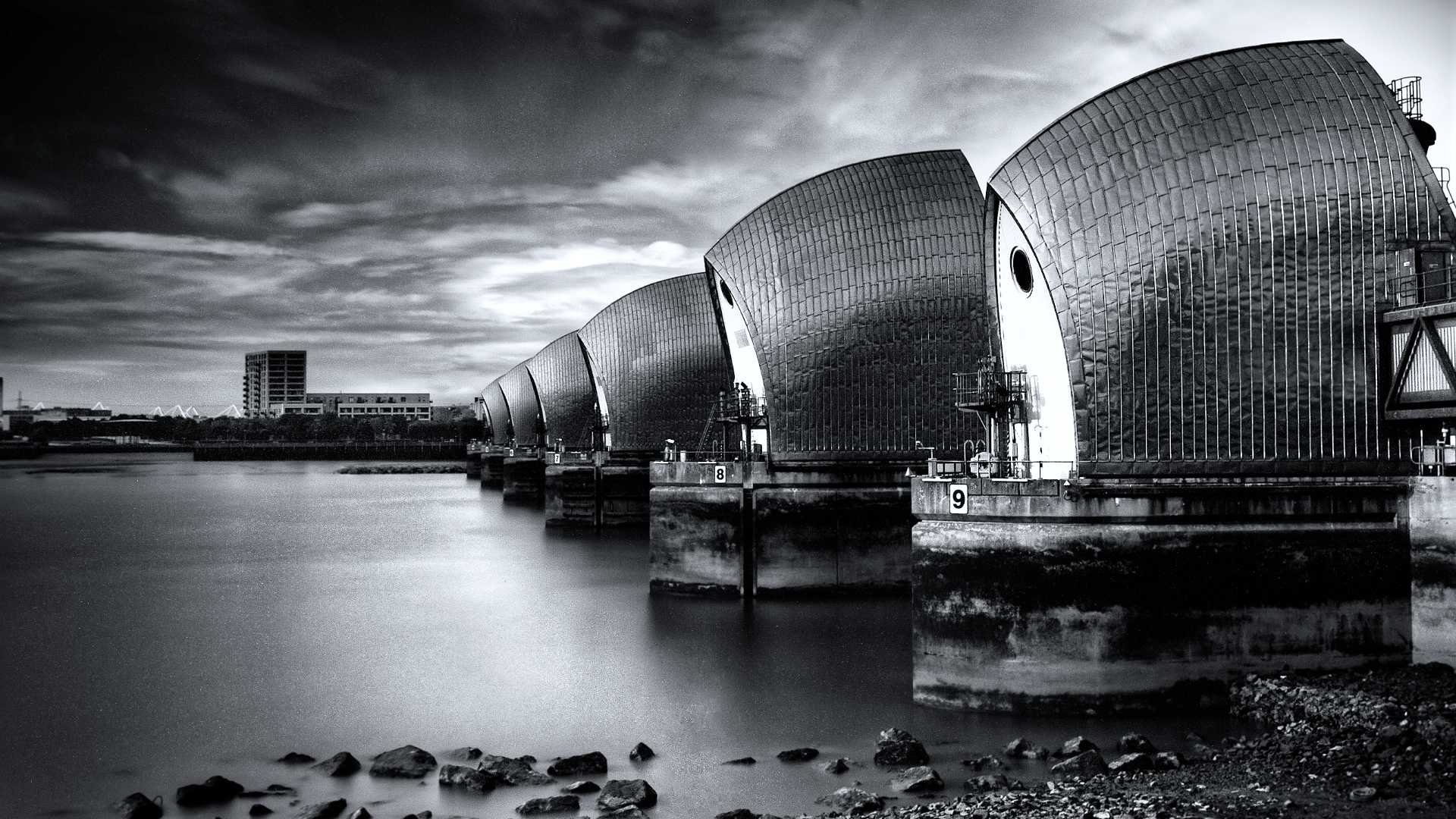
The Thames Barrier is not just a wall; it’s a machine. And it is absolutely massive.
It spans 520 metres (that’s five football pitches) across the river. It consists of 10 steel gates held between nine concrete piers—those silver-clad towers you see from the shore. These piers house the hydraulic machinery that powers the gates.
The Rotating Shield
The clever bit is how the gates move. They don’t slide across or drop down; they rotate.
- Open Position: Most of the time, the gates lie flat in concrete sills on the riverbed. Ships sail right over the top of them.
- Closed Position: When a surge is forecast, powerful hydraulic arms rotate the gates 90 degrees upwards. They stand as high as a five-storey building (20 metres) above the riverbed, creating a solid steel wall.
- Underspill Position: Sometimes, they rotate the gates just a little bit to let water flow under them. This creates a controlled current that cleans silt off the riverbed, stopping the gates from getting stuck in the mud.
Each of the main gates weighs 3,300 tonnes. To put that in perspective, that’s about the same as 275 double-decker buses. Yet, the machinery is so well-balanced that it takes just pennies worth of electricity to start them moving.
Anatomy of a Closure
Closing the barrier isn’t like shutting your front door. It’s a military-style operation that starts days in advance.
- The Watch: A team of forecasters monitors the North Sea 24/7. They look at data from satellites, tide gauges in Scotland, and weather buoys. They are looking for that deadly combination: low pressure, high winds, and high tides.
- The Alert: If a surge is spotted, the decision to close is made about 24 to 36 hours in advance. The Port of London Authority stops river traffic.
- The Button Press: There isn’t actually a single big red button, but the process is triggered from the control room on the south bank.
- The Rotation: One by one, the outer gates close first, then the middle ones. This stops the water bouncing back and creating waves. It takes about 75 minutes to close the whole thing.
- The Wait: The barrier stays shut, holding back the North Sea while the tide outside rises higher than the river inside. You can actually see the difference—water levels can be metres higher on the “sea” side than the “London” side.
- The Release: Once the tide turns and drops to the same level as the river, the gates are lowered, and the trapped river water rushes out to sea.
Working Harder Than Ever
When the barrier was designed in the 1970s, engineers thought it would be used rarely—maybe two or three times a year, purely for massive North Sea storm surges. They built it to last until 2030.
They were wrong on two counts. It’s lasting longer, but it’s working much harder.
As of early 2025, the barrier has been closed 221 times.
The Shift to “Fluvial” Flooding
Here is the twist: we aren’t just closing it for tidal surges anymore. We are closing it for rain.
In the winter of 2013/14, Britain was battered by storm after storm. The ground was soaked, and the Thames upstream (towards Oxford and Reading) was bursting its banks. A massive amount of fresh water was rushing down the river towards London.
Usually, this water drains into the sea at low tide. But if the tide is high, the river water has nowhere to go. It backs up, flooding places like Richmond and Twickenham in West London.
To stop this, the Environment Agency started closing the barrier at low tide to create a “hole” in the river for the fresh water to fill. This is called “fluvial” (river) protection, rather than “tidal” (sea) protection.
Roughly half of all closures are now to protect West London from rain, not East London from the sea. The barrier is doing double duty. It’s a shield against the sea and a plug for the river.
The TE2100 Plan: A Roadmap for Survival
We know the current barrier won’t last forever. The sea is rising. The Intergovernmental Panel on Climate Change (IPCC) and UK Met Office project that sea levels in London could rise by up to a metre by the end of the century.
So, what is the plan?
It’s called Thames Estuary 2100 (TE2100). It is an “adaptive pathway”—fancy speak for a plan that can change as the situation changes. Instead of setting a fixed date to build a new wall, the Environment Agency monitors sea levels and makes decisions based on real data.
The 2040 Deadline
For years, the plan said we didn’t need to worry about a new barrier until 2070, and we didn’t need to decide what to build until 2050.
But in 2023, the plan was updated, and the alarm bells rang a little louder. The decision date has been brought forward to 2040.
Why? Because sea levels are rising slightly faster than the “optimistic” predictions, and building big infrastructure in Britain takes a long time (just look at HS2). If we need a new barrier by 2070, we need to agree on the design, get planning permission, and find the money (likely £10 billion or more) by 2040.
We have fifteen years to make up our minds.
The Alternatives: What Comes Next?
When the silver giants finally retire, what replaces them? There are three main options on the table.
Option 1: Upgrade the Existing Barrier
We could try to make the current barrier bigger and stronger. We could add larger gates or raise the existing ones.
- Pros: It’s cheaper than building a new one. The infrastructure is already there.
- Cons: It’s incredibly difficult to do major construction work while keeping the barrier operational. If a storm hits while we are fixing the gates, London is defenceless.
Option 2: The Long Reach Barrier
This would be a new barrier further downstream, near Dartford in Kent.
- Pros: It protects more people. Areas like Dartford, Erith, and Purfleet, which are currently outside the main barrier, would be safe behind the new one.
- Cons: It’s wider, so it would cost more. It’s also a busy shipping lane.
Option 3: The Tilbury Barrier
This is the “big one.” A massive new barrier even further out, between Tilbury in Essex and Gravesend in Kent.
- Pros: This offers the maximum protection. It would turn the entire Thames Estuary into a controlled lake during storms, protecting the ports and the Gateway region.
- Cons: It would be one of the most expensive engineering projects in British history. The river is very wide here, meaning the gates would need to be titanic.
The Enemy Within: The Flood the Barrier Can’t Stop
There is a catch. A big one.
The Thames Barrier only stops water coming up the river (from the sea) or helps manage water coming down the river (from the shires). It does absolutely nothing for the rain falling on London.
This is called Surface Water Flooding, or flash flooding.
London is a concrete jungle. We have paved over our front gardens for driveways and built apartment blocks on old playing fields. When a summer “cloudburst” dumps a month’s worth of rain in an hour—like happened in July 2021—the water has nowhere to go. It can’t soak into the ground because of the concrete.
The sewers, built by the Victorians 150 years ago, are amazing, but they can’t cope with that volume. The water simply sits on the surface, flooding basements, tube stations, and roads.
In 2021, we saw videos of cars floating down streets in Maida Vale and waist-high water in Pudding Mill Lane DLR station. The Thames Barrier was open, but it didn’t matter. The water was attacking from the sky, not the river.
This is the “gap” in our defence. We are obsessed with the big silver wall, but the real danger for many Londoners is the drain outside their house blocking during a thunderstorm.
The Gamble: Are We Moving Fast Enough?
So, is London safe?
For now, yes. The Thames Barrier is a robust, well-maintained beast. It is one of the most reliable pieces of machinery on the planet. The engineers who look after it treat it with love and obsession.
But the gamble is about time.
The TE2100 plan assumes we can adapt slowly. It assumes sea levels will rise in a predictable curve. But nature doesn’t always follow our graphs. If the ice sheets in Antarctica melt faster than predicted, or if the North Atlantic gets stormier, that 2070 deadline for a new barrier might suddenly look very far away.
We are also gambling on money. A new barrier will cost billions. In a country struggling with the cost of living and pressure on the NHS, will a future government write a cheque for £10 billion for a wall that might not be needed for thirty years? Politicians often struggle to look past the next election, let alone the next century.
Conclusion
The Thames Barrier is a triumph. It is a reminder of a time when Britain built bold, futuristic things to solve big problems. It has saved London from catastrophe more than 200 times.
But the silver giants are ageing. They are working harder, closing more often, and fighting a tide that keeps getting higher. The barrier has bought us time—precious decades to plan for the future. But that time is running out.
The question isn’t if we will need a new barrier. The question is whether we will be brave enough to build it before the water arrives. Until then, the giants sleep in the river, one eye open, watching the North Sea.
Further Reading & Resources
To dive deeper into the engineering, history, and future of London’s flood defences, we recommend exploring these official and authoritative sources:
- Thames Estuary 2100 (TE2100) Plan The official government portal for the long-term flood strategy. It includes detailed maps, policy updates, and the full “adaptive pathway” reports explaining how London plans to cope with sea-level rise up to the year 2100.
- The Thames Barrier (GOV.UK) The definitive source for operational data. Check here for upcoming scheduled test closures (a great sight to see!), real-time status updates, and visitor centre information.
- London’s Surface Water Strategy Explore the Greater London Authority’s plans to tackle the “enemy within”—flash flooding and surface water risks across the capital.
- The 1953 East Coast Floods (Met Office) A detailed historical factsheet [PDF] from the Met Office archive, explaining the meteorology and impact of the disaster that led to the Barrier’s creation.
- Museum of London Docklands Located in West India Quay, this museum holds extensive archives on the history of the River Thames, trade, and the engineering feats that have shaped the Docklands.
Glossary for the Curious
- Storm Surge: A temporary rise in sea level caused by low atmospheric pressure and strong winds pushing water towards the coast.
- Fluvial Flooding: Flooding caused by a river bursting its banks due to heavy rainfall (fresh water).
- Tidal Flooding: Flooding caused by the sea rising and overflowing onto the land (salt water).
- TE2100: The “Thames Estuary 2100” plan—the government’s long-term strategy for managing flood risk in London.
- AOD (Above Ordnance Datum): The standard height used for maps in the UK. Essentially, “height above average sea level.”
Image Credit: Photo by William Warby